This year Ron and I chose a very late fall trip for several reasons. Our destination: Death Valley. The time of lowest tourist visitation: between Thanksgiving and Christmas. Daytime temperatures: the perfect 70's.
The eastern entrances to Death Valley are an easy day's drive from Flagstaff through Las Vegas. Of the two Nevada gateway towns available, Pahrump and Beatty, we chose to make Beatty our home base. It's small, about 1,100 people. It was founded in 1905 as a ranch, then transformed into the railway center for the Bullfrog Mining District. It's only a few miles away from the more famous mining ghost town of Rhyolite. Unlike Rhyolite, which boomed and busted in a mere 6 years, Beatty is still viable. It has a full slate of community services-churches, schools, park with swimming pool, museum, library, bars, restaurants, and casinos. It does, however, lack a grocery store. Dollar General doesn't count. Not sure if they go 90 miles north to Tonopah or 120 miles south to Las Vegas...either way it's a long drive!
We loved our AirBnb, a small historic home completely renovated with all conveniences.

Residences in Beatty are secured with chain link fences to keep out the local feral burros. We thought they would be plentiful, but we saw them only twice, both early in the trip. Thinking we'd see more, we didn't snap a pic and lost the opportunity!
Death Valley National Park is actually in California. Beatty is about 8 miles from the park boundry, which is also the state line.
 |
| Source: pixabay.com |
We started each morning with a sweeping and beautiful 8 mile drive.

The first day, we drove the additional 40 miles or so to the Furnace Creek Visitor's Center, all view.

We coincidentally timed our arrival at the Furnace Creek Visitor's center just right.
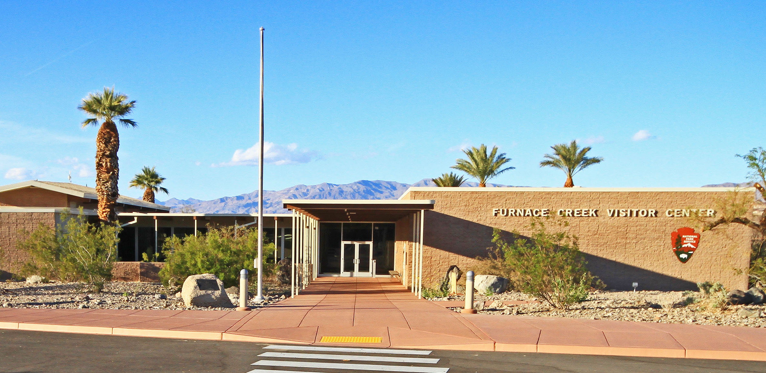 | ||||
| Source: nps.gov |
We were able to see the 20 minute intro film that NPS provides at all the parks we've been to, then drove to the 9:00 guided ranger walk/talk at Golden Canyon. The young intern did a nice job of introducing us to the fantastic geology of Death Valley.

Unlike traveling to and being in Phoenix, which doesn't feel like a valley at all to me, Death Valley looks and feels like a valley. There are relatively close mountain ranges on both sides, with the Valley itself long and relatively narrow. It's a place to dig out your geology: the pulling apart of the earth at its faults stretched the mountains apart and created the Valley.
After this walk/talk, we went back to the Visitor's Center and enjoyed the thorough and informative exhibits there. Geology, geography, biology, meteorology and humanity were all explored. The NPS sure does a nice job of providing enough information to whet the appetite!
Sticking with geology, we next took Artist's Drive, so named because of the spectacular palette of colors. The road itself is a narrow one-way rock 'n roll drive of ups and downs. It was fun!


Our afternoon visit was at Badwater Basin. It's is known for being the lowest point in North America, 282' below sea level.

In this picture, not only are you at the lowest point in North America, you're within sight of the highest point in Death Valley, Telescope Peak in the Panamint Mountains. It's a very respectable 11,049'!

This is what the salt flats look like at Badwater Basin.

At the ranger talk here, we added biology and meteorology to the mix. There actually is perennial water in the Badwater Basin. Unlike tales you might have heard or read, it isn't poisonous. However, it is amazingly saline, significantly more so than the ocean. Mother Nature doesn't care, though. She adapts. There are plants, snails and insects that live in the water at Badwater Basin.
We also learned why the Valley is so dry: there are FOUR mountain ranges between the Pacific coast and the Valley. the Coastal Mountains, the Sierra Nevadas, the Inyos, and the Panamints. Each takes their share of the moisture that travels east, and by the time the Panamints are done, well, there's next to nothing left for Death Valley.
Badwater Basin is infamous among certain runners for another reason: the Badwater Ultra Marathon. It starts here in this parking lot:

It's 135 miles of running from Badwater Basin to Whitney Portal, which is the trailhead for the Mt. Whitney trail, Mt. Whitney being the highest point in the lower 48. It's not run in the winter, either. It's run in the summer. The 2020 race is scheduled for July 6-8. The official website, www.badwater.com says, "it's the most demanding and extreme running race offered anywhere on the planet." A number of years ago a friend and I watched a movie and read some books about it. I'll take their word for it.
Zabriskie Point is noted for its sunsets. The geology was outstanding:

The sky was cloudy, though, so we chose not to hang around. However, as we drove back to the main highway it all changed, and did we ever get a Death Valley sunset!

The distances are long in Death Valley. We had an hour of driving in front of us to get back to Beatty. We had been disconcerted the previous day to realize the one-hour time difference between MST and PST meant it was dusk at 4:30 in the afternoon and full dark by 5:00. Yikes! Our late afternoon drive home was in full dark.
After yesterday's ranger talk, we started seeing Death Valley with new eyes. In fact, it's full of life and usually unique life. Adapted to extremes: extreme dryness, extreme salinity, extreme heat. It's not extravagant life. It's small, super-efficient life. You have to put on a different lens to see it.
Our second day contained a lot of the human presence in Death Valley. The ghost town of Rhyolite is representative of man's relationship with Death Valley: boom and bust in short order. A mining town with a population of ~4,000 in its heyday, there's not much left.
 | |
| Hotel/railway station/casino |
 |
| Bank with a view |
 |
| Glass bottle house |
Keane Wonder Mine was next. This mine lasted the standard ~6 years or so. The tramway visible here was about a mile long.

We visited the Harmony Borax works. Yes, this was the home of Twenty Mule Team Borax.
 |
| Source: 20muleteamlaundry.com |
There's a couple of buildings, and this original wagon set-up. That's a water tank attached to the wagons; drinking water for men and mules on the 170 mile trip to the railroad in Mohave, CA. Again, the ~5-6 year life span for this mine.

Back to nature. Devil's Golf Course is a salt flat with an entirely different manifestation than Badwater Basin.
 | ||
| These salt deposits were sharp, gnarly and unfriendly! |
On to Salt Creek, where we saw a species of minnow with the common name of pupfish. This nice boardwalk protected the creek.
 |
| Ron's focused on spotting pupfish. |

What makes pupfish remarkable is their status of super-adaptors. Each of the salt water springs in Death Valley has their own subspecies of pupfish!
Our final stop this day was the Mesquite Sand Dunes. Yes, Death Valley has it all!

Our third and last day started with an hour and a half drive to Ubehebe Crater. Go ahead and say it out loud: You-bee-hee-bee. It's fun! Yes, Death Valley also includes volcanic activity. This crater is new geologically, about 2,000 years old. It's on a more human scale, too; 2,400' in diameter, 600' deep. Gorgeous colors and formations.


Back to Stovepipe Wells area to visit Mosaic Canyon, our final stop. It's a slot canyon, and has more fabulous geology.

 | ||
| The mosaic formation for which the canyon is named. |
Most of these photos are close ups of Death Valley to show the ways it is accessible. However, when you're actually there driving through it, it doesn't feel accessible. It feels vast and barren and quiet and intimidating and timeless. And lonesome. Like this.


I shivered in those solitudes
when I heard
the voice of
the salt
in the desert.
--From "Ode To Salt" by Pablo Neruda